Philippines Earthquake
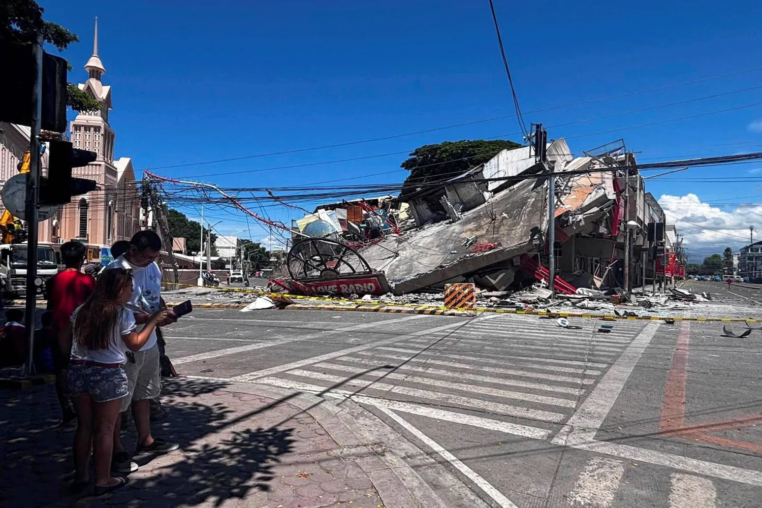
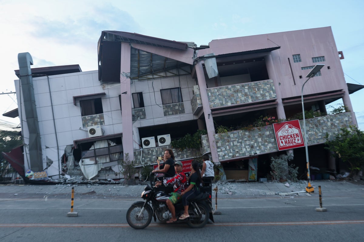
DAVAO, Philippines (AP) — An offshore earthquake with a magnitude of 7.8 hit the southern Philippines on Monday, killing at least 35 people, injuring more than 200 others mostly in ruined buildings and sending a 1-meter (3-foot) tsunami into nearby coasts.At least 35 people have died after a magnitude-7.8 earthquake struck off the coast of Mindanao island in the southern Philippines, officials say.The quake hit at 07:37 local time on Monday (Sunday 23:37 GMT), triggering tsunami alerts in the Philippines, Indonesia, Japan and Australia. The warnings were cancelled or downgraded hours later.Videos and images showed buildings collapsing, including a  clip of a Jollibee fast food restaurant reduced to rubble, and landslides have been recorded in some areas.In an update on Monday afternoon, the country's Office of Civil Defense said 31 of the fatalities had been recorded in Soccsksargen, while the other four were in Davao.Officials in the Philippines have said that at least 134 have been injured and some 10,000 families displaced.Authorities gave an earlier death toll of 32, with 12 people reported missing.Mindanao is the Philippines second-biggest island - both in size and population - and is home to around 26 million people.
Casualty numbers still need to be verified by the national disaster agency, which tabulates and verifies reports by various local sources and is expected to provide an official update in the coming days.
Several mostly low-rise buildings collapsed or sustained heavy damages in the hard-hit city of General Santos. Tsunami damage was reported in at least one southern coastal village. Smaller waves were measured in Indonesia and Palau and as far away as southern Japan.
The quake also triggered a landslide in Glan, a municipality in the province of Sarangani, that killed 13 villagers, Rene Punzalan, a provincial disaster-mitigation official, told the DZBB radio network. Four other villagers died in Sarangani, he said.
The major earthquake was the strongest to hit the Philippines this year, Teresito Bacolcol, the director of the Philippine Institute of Volcanology and Seismology, said. He warned people to seek advice before returning to damaged buildings and houses, which could collapse due to aftershocks.
The United States, a treaty ally of the Philippines, said it was coordinating with Manila and was ready to support Philippine response efforts. France, Japan and New Zealand also expressed support.
“Our pickup truck suddenly jerked and I thought we had a flat tire,” Rod Sosmeña, a regional director of the Office of Civil Defense, told The Associated Press from General Santos, where he was traveling when the quake struck at 7:37 a.m.
“The shaking was very strong and people dashed out of houses into the streets,” Sosmeña said.
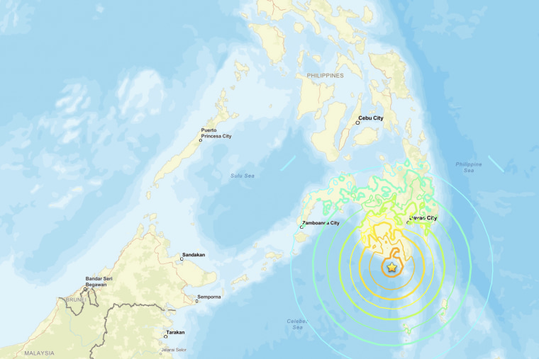
Epicenter in sea off Mindanao
More than 100 students in uniforms and a dozen teachers had gathered for a flag-raising ceremony in a coconut tree-ringed grade school compound in the rural town of Malita in Davao Occidental province when the ground shook, turning the first day of school after a two-month summer break into chaos.
“Their excitement on the first day of school turned to trauma,” school principal Rosavel Cachuela told the AP.
Some of the young students screamed in panic and wept but most remained seated and still, preventing any injuries, Cachuela said, adding that a motorcycle was damaged when a shed crumbled to the ground. At least four people remained missing in General Santos, a port city of more than 700,000 people and a regional hub for the tuna export industry. Search and rescue teams worked to find people who may have been trapped in a supermarket, a warehouse, a grade school, and other small buildings that either collapsed or were severely damaged, officials said.The international airport in General Santos was temporarily shut due to the earthquake and 17 domestic flights were canceled, the Civil Aviation Authority of the Philippines said.
The quake was centered at sea off Mindanao, the second most populous island in the Philippine archipelago. According to Bacolcol, the quake occurred at a depth of 33 kilometers (20 miles), about 32 kilometers (20 miles) southwest of Maasim town in Sarangani province.
Assessing damage and casualties
President Ferdinand Marcos Jr. ordered the cancellation of classes and directed disaster-response agencies to immediately get to work in quake-hit provinces, saying “the national government is moving and we will not leave Mindanao behind.”
The Pacific Tsunami Warning Center said the threat of a tsunami largely passed about five hours after the quake. Philippine officials also lifted a tsunami warning by mid-afternoon. Six shanties on stilts were damaged in a coastal village in Zamboanga del Sur province due to the quake and taller waves, officials said.
Aside from the landslide in Sarangani, most of the other deaths were caused by collapsing buildings and falling debris, including in a damaged mosque, in the southern provinces of South Cotabato and Davao Occidental, and on Balut Island, according to Sosmeña and another disaster-mitigation official, Ednar Dayanghirang.
The DZRH radio network in Manila reported that a four-story commercial building where its provincial station was located partly collapsed and staffers dashed to the ground floor without injuries.
Tsunami waves near 3 feet measured
Waves of 1 meter (3 feet) were monitored in the provinces of Sultan Kudarat and Sarangani. A 1.4-meter (4.6-foot) wave hit at one time in Kiamba town, Bacolcol said.
The quake was also felt in Malaysia’s Sabah state on Borneo island. Sabah is just a boat ride away from southern Philippines. An 83-centimeter (2.7-feet) tsunami was measured by a gauge off Indonesia’s Sulawesi island, and the PTWC said 30-centimeter (1-foot) waves were measured in Palau.
The quake hit early in the morning, shortly before 7:40am local time on Monday (23:40 GMT Sunday), according to the United States Geological Survey.The epicentre was offshore, 32km (20 miles) west of Maasim in Sarangani province on the southern tip of the Philippines’ Mindanao island. The earthquake occurred at an estimated depth of 33km (21 miles).Schools were reopening in the Philippines after a long break, and the tremors were felt strongly in a dozen provinces as far from the epicentre as 420km (261 miles) in the city of Manado on the Indonesian island of Sulawesi.By late morning local time, the Philippine Institute of Volcanology and Seismology had reported 138 aftershocks, the highest at a magnitude 6.7.
Waves up to 20 centimeters (7.8 inches) were detected on the remote Japanese island of Chichijima and the central Japanese town of Kushimoto, the Japan Meteorological Agency said.The Philippines is often hit by earthquakes and volcanic eruptions due to its location on the Pacific “Ring of Fire,” an arc of seismic faults around the ocean.The archipelago is also battered by about 20 typhoons and tropical storms each year, making it one of the world’s most disaster-prone countries.Gomez reported from Manila, Philippines. Associated Press writers Edna Tarigan in Jakarta, Indonesia, Eileen Ng in Kuala Lumpur, Malaysia, Mari Yamaguchi in Tokyo and global executive producer Kiko Rosario in Bangkok contributed to this report.Philippine President Ferdinand Marcos Jr said in a statement that agencies were co-ordinating their disaster response.
"The national government is moving and we will not leave Mindanao behind," he promised.Marcos also ordered the suspension of classes in affected areas after the quake, which coincided with the first day of the school year in the Philippines.In one video posted by a primary school in Davao Occidental province, dozens of terrified students can be seen squatting on the shaking ground.The video also showed a corrugated-roof shelter collapsing behind them, though the school said in its post that no-one had been injured.More than 130 aftershocks, with magnitudes ranging from 1.3 to 6.7, were recorded after the initial quake. A magnitude-5.7 earthquake also hit the water off Balut Island, Sarangani, at about 22:52 local time.
Earthquakes are common in the Philippines, which sits on the geologically unstable "ring of fire". While most of these quakes are minor and pass relatively peacefully, some have proven deadly. Last September, a magnitude-6.9 earthquake struck the central Visayas region, killing more than 70 people.Shortly after the quake on Monday morning, authorities in Japan warned of one-metre-tall tsunami waves reaching its shores.A tsunami wave measuring a few centimetres was later observed in the southern prefecture of Okinawa, while a 20cm (0.7ft) wave was measured in the distant Ogasawara Islands, authorities said.Waves were also detected at several locations along the coasts of Indonesia, Palau and the Philippines. The height of those waves ranged from a few centimetres to 1.4m (4.6ft), according to authorities.
Posted on 2026/06/09 08:40 AM